|
Official race information can be found by contacting the named race.
Barr Trail Mountain RaceThe start is on Ruxton Avenue by the COG railway depot at an elevation of 6,570'. The race will proceed 6 miles up the Barr Trail gaining 3,630' where it will turn around at Barr Camp at 10,200'. Runners will then head back down the Barr Trail to Hydro Street with the finish being near the Barr Trail trail-head parking lot for a total of 12 miles. The cut-off for the race is 3 hours and 30 minutes. There will be 9 aid stations located at the start/finish, 1.5/10.5 mile, 2.75/9.25 mile, 4/8 mile, and the 6 mile point turn-around point at Barr Camp.
Mount Washington Road Race
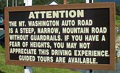 The “Beast from the East” has also been a stomping ground of mine. The “Race to the Clouds” starts at 1,638' and
rises 4,650' to the highest peak in the Northeast at 6,288' above sea level. The road surfaces is alternately asphalt 60% and dirt 40%,
winding 7.6 miles up at an average gradient of 11.5%.
The “Beast from the East” has also been a stomping ground of mine. The “Race to the Clouds” starts at 1,638' and
rises 4,650' to the highest peak in the Northeast at 6,288' above sea level. The road surfaces is alternately asphalt 60% and dirt 40%,
winding 7.6 miles up at an average gradient of 11.5%.
The race takes place on the third Saturday in June. To get into the lottery your entry must be received by March 15 of that year.
To get an entry [it‘s not the 90s anymore - just go online!]
send a S.A.S.E. to: Mount Washington Road Race, Granite State Race Services, P.O. Box 990, Newport, NH 03773-0990.
Because there are only 1000 spots available — with most of them given away in the lottery — it can be pretty hard to get into
this race! There is a lottery bypass if you:
Here is the Mt. Washington Road Race home page with just about everything you would want or need to know about the race.
Skyrunning – Where sport becomes survival... Although I have done about a dozen SkyMarathons, none stand out in my mind like the Fila Tibet TopMarathon.
From September 4 through October 5, 1995, I was in Nepal and Tibet to participate in the World‘s Highest Marathon held at a constant elevation
of 17,060 feet (5,200 meters)! When I did simular races in 1993, 1994, 1996 and 1998 there were held at only 14,350 feet.
Sure the races are insane and the plane trips can get scary, but the trip is a once in a lifetime experience! Well, if you win, more than once;-)
Although I have done about a dozen SkyMarathons, none stand out in my mind like the Fila Tibet TopMarathon.
From September 4 through October 5, 1995, I was in Nepal and Tibet to participate in the World‘s Highest Marathon held at a constant elevation
of 17,060 feet (5,200 meters)! When I did simular races in 1993, 1994, 1996 and 1998 there were held at only 14,350 feet.
Sure the races are insane and the plane trips can get scary, but the trip is a once in a lifetime experience! Well, if you win, more than once;-)
Stories:
Videos:
Vail Hill Climb Another favorite mountain of mine is Vail mountain, home of the Vail Hill Climb! It gains 2,000 feet in 7.5 miles. Here are live webcams on Vail mountain. The fine people at Vail moved the race start in 1995. I guess that is one way for them to get a new course record:-)
More photos...
|

 The
The 